


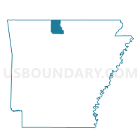
NORTH FORK Voting District, Marion County, Arkansas
About
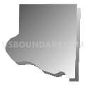
Outline

Summary
| Unique Area Identifier | 527258 |
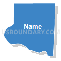
| Name | NORTH FORK Voting District |
| County | Marion County |
| State | Arkansas |
| Area (square miles) | 43.48 |
| Land Area (square miles) | 32.12 |
| Water Area (square miles) | 11.36 |
| % of Land Area | 73.87 |
| % of Water Area | 26.13 |
| Latitude of the Internal Point | 36.44927260 |
| Longtitude of the Internal Point | -92.57813600 |
Maps


Graphs
Select a template below for downloading or customizing gragh for NORTH FORK Voting District, Marion County, Arkansas


Neighbors
Neighoring Voting District (by Name) Neighboring Voting District on the Map
- Voting District 1-2, Baxter County, AR
- Voting District 2-3, Baxter County, AR
- Big Creek Voting District, Ozark County, MO
- CEDAR CREEK Voting District, Marion County, AR
- JAMES CREEK Voting District, Marion County, AR
- KEETER Voting District, Marion County, AR
- Pontiac Voting District, Ozark County, MO
Top 10 Neighboring County Subdivision (by Population) Neighboring County Subdivision on the Map
- Marion County township, Marion County, AR (16,653)
- Grover township, Baxter County, AR (2,438)
- Logan township, Baxter County, AR (1,566)
- Big Creek township, Ozark County, MO (973)
- Pontiac township, Ozark County, MO (317)
Top 10 Neighboring Place (by Population) Neighboring Place on the Map
Top 10 Neighboring Unified School District (by Population) Neighboring Unified School District on the Map
- Mountain Home School District, AR (33,097)
- Flippin School District, AR (7,226)
- Ozark Mountain School District, AR (5,101)
- Gainesville R-V School District, MO (4,526)
- Lutie R-VI School District, MO (1,635)
Top 10 Neighboring State Legislative District Lower Chamber (by Population) Neighboring State Legislative District Lower Chamber on the Map
- State House District 143, MO (38,454)
- State House District 81, AR (30,298)
- State House District 86, AR (28,614)
Top 10 Neighboring State Legislative District Upper Chamber (by Population) Neighboring State Legislative District Upper Chamber on the Map
Top 10 Neighboring 111th Congressional District (by Population) Neighboring 111th Congressional District on the Map
- Congressional District 3, AR (822,564)
- Congressional District 1, AR (687,694)
- Congressional District 8, MO (656,894)
Top 10 Neighboring Census Tract (by Population) Neighboring Census Tract on the Map
- Census Tract 9508, Baxter County, AR (6,097)
- Census Tract 9603, Marion County, AR (5,178)
- Census Tract 4701, Ozark County, MO (4,819)
Top 10 Neighboring 5-Digit ZIP Code Tabulation Area (by Population) Neighboring 5-Digit ZIP Code Tabulation Area on the Map
- 72653, AR (28,560)
- 72687, AR (6,461)
- 65655, MO (3,186)
- 72642, AR (1,979)
- 72619, AR (1,936)
- 65761, MO (1,273)
- 72661, AR (580)
- 65729, MO (264)